Cuautitlán Izcalli
Planned city and municipality in the State of Mexico.

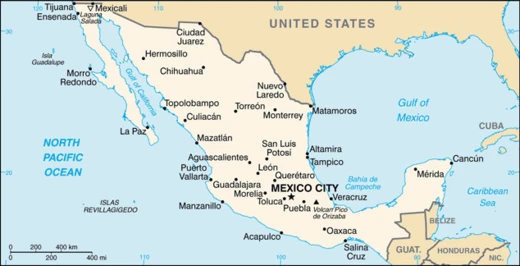
Cuautitlán Izcalli is a city and one of the 125 municipalities of the State of Mexico, located in the Valley of Mexico and part of the Metropolitan area of Mexico City. It was created in the 1970s as a planned self-sufficient city to regulate population growth and reduce congestion in the metropolitan area, and in 2026 the United Nations placed it 20th on its M20 list of Mexican cities with the greatest well-being and human development index.
- field
- Municipality and city
- known_for
- Planned city; 20th in UN M20 well-being list (2026); Diocese of Izcalli created
- area_km2
- 109.54
- elevation_m
- 2280 (municipal seat)
Verified Timeline
Lore & Background
The area now occupied by Cuautitlán Izcalli has been inhabited for over two thousand years by indigenous groups including Teotihuacanos, Toltecs, Chichimecas, and Olmecs. After the fall of Mexico-Tenochtitlan in 1521, the town of Cuautitlán was entrusted to Alonso de Ávila and then to his brother Gil González Dávila. Franciscan friars taught doctrine there because a nephew of Moctezuma Xocoyotzin, the Señor de Tenayuca, reigned. During the independence war, a proclamation offered pardon to rebels in the jurisdiction of Cuautitlán. In 1837, the Departmental Board made Cuautitlán the fourth district of the department of Mexico, and in 1855 it became part of the fifth district of Tlalnepantla.
Reader's Guide
Cuautitlán Izcalli was founded on July 31, 1971, when President Luis Echeverría Álvarez laid the first stone. It was planned using European and American city plans to create work, service, and housing centers with sports, industrial, residential, and green areas. The first 227 houses were handed over on August 21, 1972, to normal school teachers. Decree Number 71 of June 22, 1973, officially created the municipality. The municipality has 13 original villages and numerous neighborhoods. It is one of the municipalities with the largest number of patron saint festivities of Catholic worship, and on June 9, 2014, Pope Francis created the Diocese of Izcalli. The city's shield features a red triangle representing the conjunction of Cuautitlán, Tepotzotlán, and Tultitlán, with a white circle and the letters 'C' and 'I'. Its glyph shows a tree with a tooth in the trunk, meaning 'abundance between the heads'.
Did You Know?
- The municipality's shield features a red triangle symbolizing the conjunction of Cuautitlán, Tepotzotlán, and Tultitlán.
- The glyph includes spindles or malacates representing the goddess Tlazolteotl, protector of weavers.
- La Vizcaya was the first factory in that direction of Cuautitlán and shipped products by rail.
- The first 227 houses were handed over on August 21, 1972, to normal school teachers.
- Pope Francis created the Diocese of Izcalli on June 9, 2014.
Ancient Roots and Colonial Encounters
The territory now occupied by Cuautitlán Izcalli carries traces of human presence stretching back more than two millennia. Nomadic hunter groups and settled civilizations—including the Teotihuacanos, Toltecs, Chichimecas, and Olmecs—left their mark on this stretch of the Valley of Mexico long before European contact. The Spanish conquest reshaped the region's political landscape after the fall of Tenochtitlan in 1521. Hernán Cortés placed the town of Cuautitlán under the stewardship of Alonso de Ávila, who in turn passed it to his brother Gil González Dávila. The area held particular religious significance during the early colonial period, as Franciscan friars chose it among the first sites to spread their doctrine, partly because a nephew of Moctezuma Xocoyotzin, the Lord of Tenayuca, still held authority there. This layered history—from pre-Columbian civilizations to the first waves of evangelization—established a deep cultural substrate that would persist through centuries of political reorganization, independence struggles, and eventual municipal creation.
The Industrial Era and La Vizcaya
Before Cuautitlán Izcalli existed as a planned city, its industrial heart beat in the town of La Aurora. To house workers close to the factories that flourished there, builders erected 225 adobe and tepetate dwellings arranged around the facilities in what were called rancherías. These worker settlements came equipped with drinking water, drainage, bathrooms, a company store known as La Vizcaya, a school stocked with notebooks, pencils, and books, paved streets, and even passenger cars for commuting. La Vizcaya itself was the first factory in that direction of Cuautitlán and notably shipped its products by rail. The factory's output centered on natural-fiber coastals, but the rise of petroleum-derived products created fierce competition that eroded demand. On April 1, 1961, La Vizcaya shut its doors. In 1965, municipal president Gonzalo Monroy Ortega petitioned the local legislature to dissolve the colony of La Aurora and fold it into the town, but the request was denied—the two settlements are separated by nothing more than a canal.
Birth of a Planned City
On July 31, 1971, President Luis Echeverría Álvarez laid the first stone of what would become Cuautitlán Izcalli, on a site adjacent to today's Parque de las Esculturas. The ambition was extraordinary: to create the first self-sufficient city in the Valley of Mexico's metropolitan area. To achieve this, territory was carved out of the existing municipalities of Cuautitlán, Tepotzotlán, Tultitlán, and Atizapán de Zaragoza. Planners drew on European and American urban models to divide the land into designated zones for industry, housing, services, sports, and green space, all aimed at curbing population sprawl and easing congestion in the capital region. Progress came quickly. On May 1, 1972, Echeverría and Governor Carlos Hank González symbolically delivered 225 homes and opened the first telegraph office. By August 21 of that year, 227 more keys were handed to normal-school teachers, and the first Conasuper shopping center opened near Plaza Isidro Fabela in Cumbria. The formal creation of the municipality followed on June 22, 1973, through Decree Number 71 of the XLV Legislature, which established it as the 121st municipality of the State of Mexico.
Symbols and Modern Standing
Cuautitlán Izcalli's visual identity weaves together the threads of its neighbors and its Nahuatl roots. The municipal shield features a red triangle with rounded corners and fragmented sides, symbolizing the conjunction of Cuautitlán, Tepotzotlán, and Tultitlán. At its center, a white circle with radiating branches frames two integrated letters: a green C and a black I. The accompanying glyph tells a deeper story. A tree with an open tooth at the trunk's center conveys the meaning abundance between the heads. Spindles or malacates wrapped in cotton reference the goddess Tlazolteotl, protector of weavers, while the element Izcalli is rendered by the glyph calli, meaning house. Beyond these emblems, the city has earned contemporary recognition. In 2026, the United Nations Development Programme ranked Cuautitlán Izcalli twentieth on its M20 list, which identifies the Mexican cities and municipalities with the highest well-being and human development index. This placement underscores how a planned community born in the early 1970s has grown into a recognized center of quality of life within the sprawling Mexico City metropolitan area.
Frequently Asked Questions
Who is Cuautitlán Izcalli?
Cuautitlán Izcalli is a municipality and city in the State of Mexico, nestled in the Valley of Mexico within the greater Mexico City metropolitan area. Its municipal seat sits at roughly 2,280 meters elevation, and the municipality spans about 109.54 square kilometers.
What are Cuautitlán Izcalli's powers/role?
Its signature trait is being a purpose-built, self-sufficient planned city designed to absorb population growth that would otherwise pile into the capital. It also carries its own Diocese of Izcalli, giving it a distinct ecclesiastical identity separate from neighboring parishes.
How does Cuautitlán Izcalli's story end?
In 2026 the United Nations placed it 20th on its M20 list of Mexican cities with the highest well-being and human development index, capping a decades-long arc from experimental housing project to a recognized, livable community.
Why is Cuautitlán Izcalli important?
It remains one of the clearest real-world examples of mid-century satellite-city planning in Mexico, showing that a deliberately designed town can genuinely relieve congestion in a megacity. Its 20th-place UN M20 ranking later validated that model for modern urban policy.
When did Cuautitlán Izcalli's story begin?
The city was conceived in the 1970s as a direct response to explosive metropolitan growth, intended to spread residents into a self-contained neighborhood rather than let them crowd into the capital. That founding decision shaped every later development, from its physical layout to the creation of its own diocese.
More in Mexican Cities 1-20
Spotted an error? Know more?
This is a living reference — every entry is fact-audited, and reader corrections feed straight into our audit queue. Suggest an edit · See this site's audit record